Thanks to Callisto Lodwick for today’s guest post! This is the first in a series of posts by students working on the project with funding from the St Andrews Research Internship Scheme.
This walk takes you up to the Hippocrene spring on Zagaras, the eastern peak of Mount Helikon.

Hesiod on Mount Helikon
Mount Helikon, rising from the west of the Boiotian plain, has long been at the forefront of Greek thought. Hesiod famously mentions it in the opening of his Theogony, his epic poem charting a version of the ancient Greek creation myth:
From the Helikonian Muses let us begin to sing, who hold the great and holy peak of Helikon, and who dance around the violet-coloured spring and the altar of all-powerful Zeus with soft feet, and having washed their delicate bodies in Permessos or in the Hippocrene Spring or sacred Olmeios, make their beautiful, lovely dances on highest Helikon, moving nimbly with their feet… (Hesiod, Theogony 1-8)
Though Hesiod bemoaned the poverty of his hometown, ‘near Helikon in a miserable village, Askra, bad in winter, unpleasant in summer, never good’ (Hesiod, Works and Days 639-40), it was still his home, and the beauty of the upper slopes of the mountain pervades his descriptions.
Helikon is exceptionally beautiful to this day: the lower slopes are shaded by pine forests, which gradually give way to wild flower-filled meadows. You can still see goatherds grazing their flocks on the lower slopes today. It’s easy to imagine the pastoral landscape described by Hesiod, and even simpler to understand how his imagination was piqued to imagine gods and nymphs frolicking among the flowers.

Zagaras and the Valley of the Muses
‘Finding’ Helikon today can be a little tricky, because the name Helikon is applied to the whole range stretching east-west. For those interested in scaling the historical Helikon, you want the Zagaras peak, the one furthest to the east that towers above the Valley of the Muses.
By the third-century BCE, this valley was the site of a Mouseion (a holy site dedicated to the Muses), complete with an altar, stoas, sculptural groups of the Muses, Apollo, Hermes, and Dionysus, and a theatre for hosting musical competitions.
The site even claimed to possess a poetic tripod Hesiod won in a legendary contest against Homer. In the Roman period, dedicatory sculptures to the cult of the imperial family were added, tying the Muses and Hesiod’s poetry into the power of the Julio-Claudian dynasty.
The Hippocrene spring
A notable landmark from Hesiod’s writing is the Hippocrene Fountain, literally Horse’s Spring.
According to legend, this stream was created when Pegasus, the famed winged horse, stamped his foot upon the mountainside. The stream was praised in ancient times: Nonnus called the water ‘honey-dripping’ (Dionysiaca 7.235), and the allure of the spring being the spot where the Muses’ bathed no doubt contributed to its draw.
Callimachus had the goddess Athena bathe here when she was discovered by the youth Teiresias: in her rage, she blinded him, then bestowed upon him the gift of prophecy after an appeal from his distraught mother (Hymn 5.70-136). The tale also bears striking parallels to the tale of Aktaion, who is said to have died for committing a similar transgression on Mount Kithairon, about ten miles to the south-east.
Kithairon and Helikon occupied similar spaces in the ancient mind: a fragment from the archaic Boeotian poet Korinna sets the two mountains against each other in a personified heroic struggle.
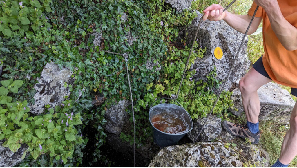
The spring is still there today, within the cleft of a rock covered by tresses of ivy and shaded by a pine tree. A small bucket tied to a rope allows you the unique opportunity to sample the water (though the number of flies and debris coating the surface might make you think twice).

The route
To hike to the spring, walk or drive south from Evaggelistria along a winding switchback road. Turn left at a junction and continue until you reach this spot (38.329507, 23.023991; https://maps.app.goo.gl/w6YMYKhybh6QF3858), where you’ll find a cow shelter and small fountain.
Alternatively you can approach from the east (see the route map below), driving along the road from the village of Askri to the Valley of the Muses, and then walking along the track westwards from there.
The route up is steep and marked only intermittently with bright red tape: you will need to be prepared to do your own route finding and be in good physical fitness. You climb through a meadow, turn left to enter the deciduous montane forest, then climb steeply up rocky paths until you enter the pines.
These pines become shorter and stouter as the path continues to climb, until you find yourself pushing through groves of five-to seven-foot trees that cling precariously to a scree slope. Once you finally leave the trees, you’ll find yourself in a meadow: keep climbing up and to the left (due southeast) and you will find the Hippocrene.

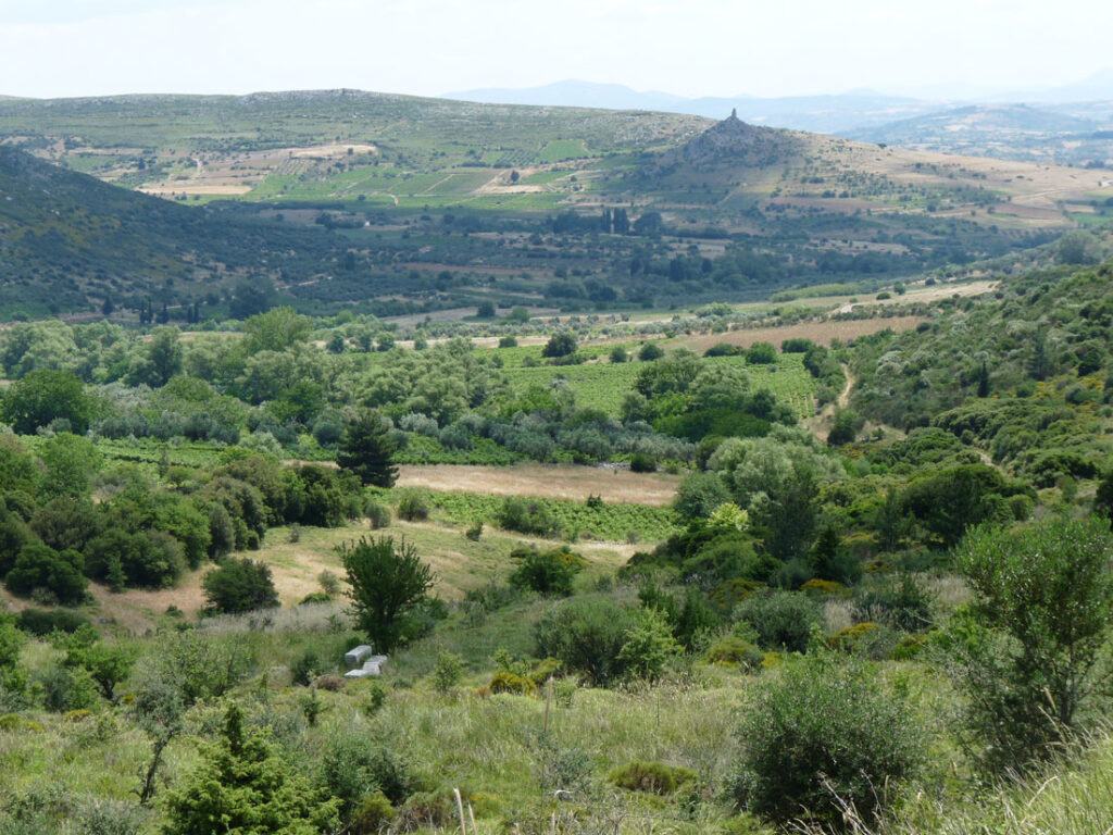
View looking north from the Hippocrene Spring. Note the squat, waist-high pine trees: the route up is choked with them, but by the time you reach them you know you’re getting close.
If you want to carry on to Motsara, the highest summit of Zagaras, the route along the ridge is fairly straightforward. It’s quite rough ground, but by the time you’ve reached the spring you’ve done the vast majority of the climbing, so there’s not much additional ascent.
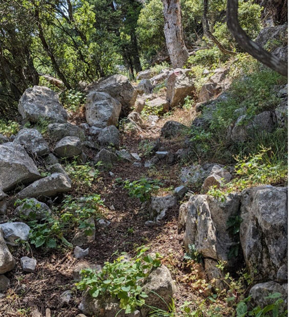
Typical path through the lower deciduous forest. Note the poor signposting and rough terrain: you must be prepared for the possibility of backtracking. A compass and good map are a must.

View looking back from the top of the scree slope. The sheer steepness doesn’t translate well to camera, but it’s possible to get a sense of how rough the terrain becomes. This section is slow-going and should be taken with caution, especially on the descent.

From the Valley of the Muses to the Hippocrene Spring and back is about 13 km and 870 metres of ascent.
The start point for the route is here. The downloadable gpx file is here: